


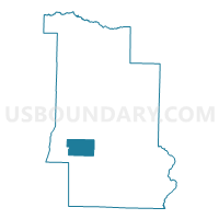
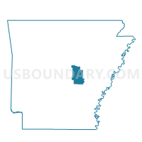
WALLS Voting District, Lonoke County, Arkansas
About
Outline

Summary
| Unique Area Identifier | 527205 |
| Name | WALLS Voting District |
| County | Lonoke County |
| State | Arkansas |
| Area (square miles) | 17.94 |
| Land Area (square miles) | 17.17 |
| Water Area (square miles) | 0.77 |
| % of Land Area | 95.68 |
| % of Water Area | 4.32 |
| Latitude of the Internal Point | 34.66353870 |
| Longtitude of the Internal Point | -91.97953980 |
Maps

Graphs
Select a template below for downloading or customizing gragh for WALLS Voting District, Lonoke County, Arkansas


Neighbors
Neighoring Voting District (by Name) Neighboring Voting District on the Map
- DORTCH Voting District, Lonoke County, AR
- LAFAYETTE Voting District, Lonoke County, AR
- PETTUS Voting District, Lonoke County, AR
- RICHWOODS Voting District, Lonoke County, AR
- WILLIAMS Voting District, Lonoke County, AR
Top 10 Neighboring County Subdivision (by Population) Neighboring County Subdivision on the Map
- Williams township, Lonoke County, AR (498)
- Lafayette township, Lonoke County, AR (308)
- Richwoods township, Lonoke County, AR (193)
- Pettus township, Lonoke County, AR (168)
- Dortch township, Lonoke County, AR (132)
- Walls township, Lonoke County, AR (111)
Top 10 Neighboring Unified School District (by Population) Neighboring Unified School District on the Map
- Pulaski County Special School District, AR (152,855)
- Lonoke School District, AR (9,959)
- England School District, AR (4,198)